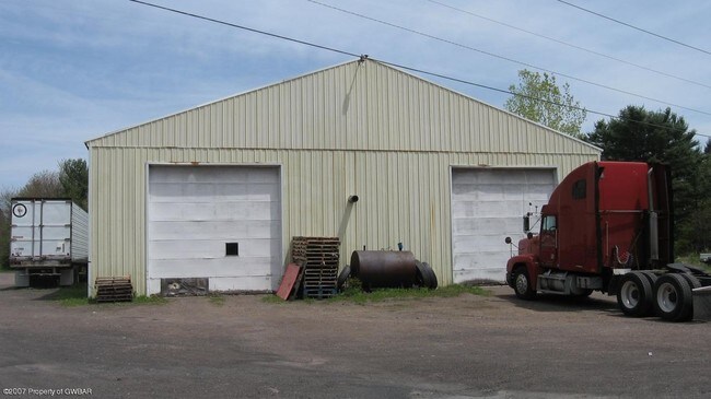
Property Record
Route 118, Dallas, PA 18612

NEARBY LISTINGS FOR SALE OR LEASE
Property Detail
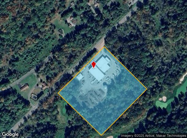
Route 118
Scranton--Wilkes-Barre--Hazelton, PA
40-11-1-D2-D1-5 ROUTE 00118
40-E7-00A-19A-000
Luzerne
Governmentalpublicusegeneral
Pennsylvania
X
19a
42079C0185E
9 AC
2025
I-81 Corridor
2025
Philadelphia
211204
DEMOGRAPHICS near Route 118
1 Mile
3 Mile
5 Mile
2024 Total Population
440
11,835
29,580
2029 Population
433
11,958
30,070
Pop Growth 2024-2029
(1.59%)
+ 1.04%
+ 1.66%
Average Age
46
45
44
2024 Total Households
188
4,371
11,383
HH Growth 2024-2029
(1.60%)
+ 1.28%
+ 1.98%
Median Household Inc
$107,353
$94,693
$90,469
Avg Household Size
2.30
2.20
2.30
2024 Avg HH Vehicles
2.00
2.00
2.00
Median Home Value
$280,644
$257,093
$231,462
Median Year Built
1971
1977
1975
Nearby Places
Map Layers
Map Styles
 Street
 Aerial
- Restaurants
- Banks
- Shops
- Fitness
- Groceries
PUBLIC TRANSPORTATION
AIRPORT
Wilkes-Barre/Scranton International
DRIVE
WALK
Distance
Wilkes-Barre/Scranton International
38 min
22.4 mi
Nearby Properties
Address
Land Use
TOTAL SIZE
Lot Size
Zoning
Address
Land Use
TOTAL SIZE
Lot Size
Zoning
44.13 AC
Address
Land Use
TOTAL SIZE
Lot Size
Zoning
Address
Land Use
TOTAL SIZE
Lot Size
Zoning
37.44 AC
Address
Land Use
TOTAL SIZE
Lot Size
Zoning
57.68 AC
Address
Land Use
TOTAL SIZE
Lot Size
Zoning
15.71 AC
Address
Land Use
TOTAL SIZE
Lot Size
Zoning
13.04 AC
Address
Land Use
TOTAL SIZE
Lot Size
Zoning
17.53 AC
Address
Land Use
TOTAL SIZE
Lot Size
Zoning
6.77 AC
Address
Land Use
TOTAL SIZE
Lot Size
Zoning
4.73 AC
Address
Land Use
TOTAL SIZE
Lot Size
Zoning
15.56 AC
Address
Land Use
TOTAL SIZE
Lot Size
Zoning
6.92 AC
Address
Land Use
TOTAL SIZE
Lot Size
Zoning
1.35 AC
Address
Land Use
TOTAL SIZE
Lot Size
Zoning
Address
Land Use
TOTAL SIZE
Lot Size
Zoning
Address
Land Use
TOTAL SIZE
Lot Size
Zoning
997 SF
488 AC
Address
Land Use
TOTAL SIZE
Lot Size
Zoning
2.97 AC
Address
Land Use
TOTAL SIZE
Lot Size
Zoning
5.05 AC
Address
Land Use
TOTAL SIZE
Lot Size
Zoning
8.25 AC
Address
Land Use
TOTAL SIZE
Lot Size
Zoning
42.39 AC
Address
Land Use
TOTAL SIZE
Lot Size
Zoning
35.95 AC
Address
Land Use
TOTAL SIZE
Lot Size
Zoning
4.29 AC
Address
Land Use
TOTAL SIZE
Lot Size
Zoning
Address
Land Use
TOTAL SIZE
Lot Size
Zoning
10.79 AC
Address
Land Use
TOTAL SIZE
Lot Size
Zoning
10.37 AC
Address
Land Use
TOTAL SIZE
Lot Size
Zoning
5 AC
Address
Land Use
TOTAL SIZE
Lot Size
Zoning
Address
Land Use
TOTAL SIZE
Lot Size
Zoning
1.25 AC
Address
Land Use
TOTAL SIZE
Lot Size
Zoning
Address
Land Use
TOTAL SIZE
Lot Size
Zoning
3.36 AC
Address
Land Use
TOTAL SIZE
Lot Size
Zoning
1.32 AC
The World's #1 Commercial Real Estate Marketplace
Connect with us
© 2025 CoStar Group
The information above has been obtained from sources believed reliable. While we do not doubt its accuracy we have not verified it and make no guarantee, warranty or representation about it. It is your responsibility to independently confirm its accuracy and completeness. Any projections, opinions, assumptions, or estimates used are for example only and do not represent the current or future performance of the property. The value of this transaction to you depends on tax and other factors which should be evaluated by your tax, financial, and legal advisors. You and your advisors should conduct a careful, independent investigation of the property to determine to your satisfaction the suitability of the property for your needs.